
Western Canadians may not be out of the woods on winter after the late arrival of La Niña. And climate change advocacy has taken a hit after an expected return of cold Artcic conditions.
That's because weather experts officially marked the arrival of the meteorological phenomenon into the equatorial Pacific — days late and dollars short — amid growing skepticism over climate modelling to forecast long-term temperature patterns.
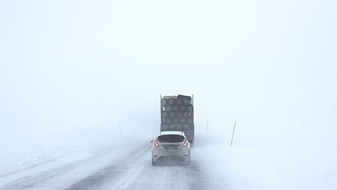
Environment Canada on Thursday predicted a shift to normal or below-normal winter temperatures across British Columbia and the Prairies, following a mild start to the season.
According to the meteorological magicians, the turn could come as soon as the second or third week in January and last until May.
It validates the view of climate scoffers that the science is still far from settled. The bad news is that forecasters are predicting a return to bitterly cold winter temperatures after an unusually mild fall across Western Canada.
La Niña translates to ‘El Viejo’ in Spanish, or simply ‘a cold event’.
It occurs when sea surface temperatures in the eastern Pacific Ocean drop by at least 0.5C below normal for several consecutive months. These cooler waters affect global weather patterns, often bringing colder, wetter winters to Western Canada and drier, milder conditions to Eastern Canada.
But this La Niña has been anything but typical and is being described as "puzzling" from a meteorological perspective.
That's because it arrived months later than expected and experts from both the US National Oceanic and Atmospheric Administration (NOAA) and the United Nations’ World Meteorological Organization (WMO) agree that this year’s will be weaker and shorter than previous editions.
Despite months of atmospheric patterns behaving as though La Niña was already in effect, ocean temperatures only recently hit the threshold to declare the event official.
“It’s totally not clear why this La Niña is so late to form, and I have no doubt it’s going to be a topic of a lot of research,” said Michelle L’Heureux, head of NOAA’s El Niño team.
The delayed and weakened La Niña has sparked a broader discussion about the challenges of accurately predicting long-term weather patterns in a rapidly changing climate. While seasonal forecasts still rely heavily on El Niño and La Niña cycles, experts caution that climate change may be altering the frequency, intensity and timing of these events in ways that are not yet fully understood.
Despite the weaker La Niña, Western Canada is still expected to see below-seasonal temperatures this winter, with the usual Arctic air masses already settling across the region. Meanwhile, Eastern Canada is likely to remain warmer than average, according to Environment Canada’s latest seasonal outlook.
In addition to La Niña, forecasters are watching the Pacific Decadal Oscillation (PDO) — a longer-term fluctuation in Pacific Ocean temperatures — which could reinforce the colder weather patterns in the West this winter.
Still, experts remain cautious about making firm predictions calling into question the reliability of traditional weather models and how climate systems behave in a warming world.
While Canadians bundle up for a colder winter ahead, the question remains: How well do scientists really understand what’s coming next?
The good news for farmers is that it means more moisture over typically drier winter months. Amend skiers can look forward to copious amounts of powder up in the hills just in time for spring ski season -- global warming be damned.
